Beijing Maps
Beijing maps include the Beijing district map, the Beijing subway map, and the Beijing tourist map. These maps can also help you to travel all over Beijing, even without the help of mobile navigation.
Beijing on the World Map
Beijing is located in the northern hemisphere, to the east of the world's largest continent - Eurasia, and to the west of the world's largest ocean - the Pacific Ocean.

Beijing Location on the China Map
Beijing is located in the north of China, northwest of Shanghai, north of the North China Plain, and adjacent to Tianjin to the east, as well as to Hebei Province in other directions.
Beijing District Map
Beijing has a total of 16 administrative districts. The main urban areas include Dongcheng District, Xicheng District, Chaoyang District, Haidian District, Fengtai District, and Shijingshan District.
The initially chosen location for Beijing Capital International Airport was Shunyi County in Hebei Province (Shunyi District in Beijing). At that time, the airport was subordinate to the Chaoyang District in Beijing. Later, Shunyi was incorporated into Beijing and renamed as Shunyi District.
Beijing Ring Map
Beijing has six ring roads, the innermost of which is the Second Ring Road. The construction of Beijing's ring roads began in 1958, but they were not connected at that time. There were only the Northern Ring Road, the Southern Ring Road, and the Eastern Ring Road, which people habitually referred to as the "3 ring roads".
Because this name was popular, the road was named the Third Ring Road. Later, a ring road was built inside and outside the Third Ring Road, becoming the Second Ring Road and the Fourth Ring Road.
Beijing Hutong Map
There are thousands of hutongs around the Forbidden City, most of which were formed during the Yuan, Ming, and Qing dynasties. Among them, the most lively one is Nanluoguxiang, where there are shops and restaurants built in the style of ancient Chinese architecture. Other famous hutongs include Yandaixie Street, Liulichang, and Maoer Hutong.
Beijing Transportation Map
Beijing has 2 airports, Capital Airport and Daxing Airport, and 4 main railway stations, namely Beijing Railway Station, Beijing West Railway Station, Beijing South Railway Station, and Beijing Chaoyang Railway Station. Both the airport and railway stations can be reached by taking the Beijing Subway.
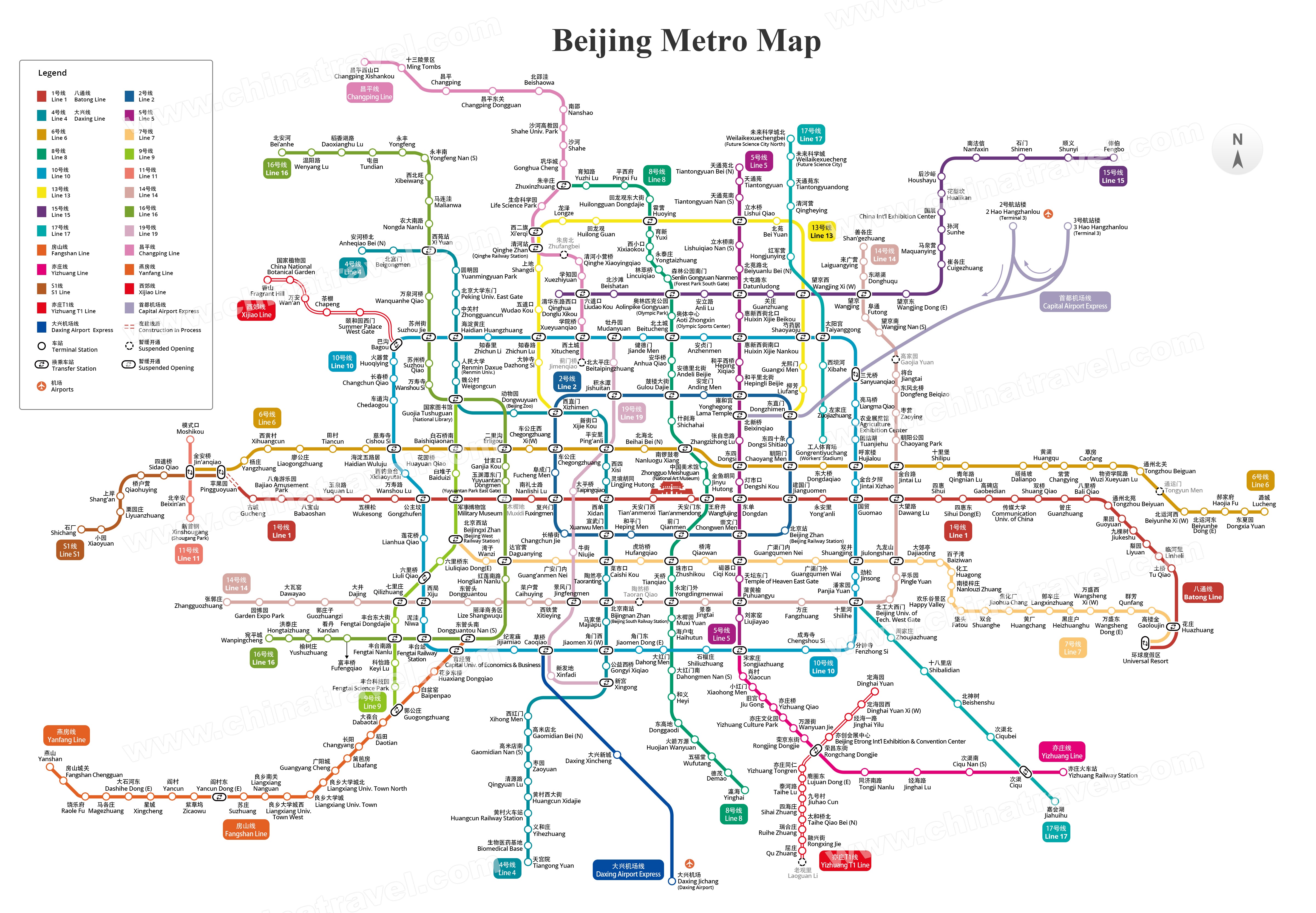
Beijing Subway Map
Beijing Subway Line 1 began operation in 1971, making Beijing the first city in China to open a subway. As of 2023, Beijing has opened 27 rail transit lines, and most subway lines operate from 5: 00 to 11:00.
Beijing Capital Airport to City Center Map
Beijing Capital Airport is 25 kilometers away from the city center. The subway that opened at this airport is the Capital Airport Express. The bus stations of the Capital Airport shuttle bus are located at Gate 11, 1st floor, T2 terminal, and Gate 1, 1st floor, T3 terminal.
Beijing Daxing Airport to Downtown Map
Beijing Daxing Airport opened in 2019, 46 kilometers away from the Palace Museum. The subway that opened at this airport is the Daxing Airport Express. You can buy the tickets for the airport bus next to gate 20 on the first floor.
Beijing to Xi'an Map
Beijing is approximately 1100 kilometers away from Xi'an. Traveling from Beijing to Xi'an takes about 4 hours by high-speed train and 2 hours by plane.
Beijing to Shanghai Map
Beijing is more than 1300 kilometers away from Shanghai, yet it only takes 4 hours and 18 minutes to get there by high-speed train from Beijing, and 2 hours by plane.
Great Wall Map
The distribution of the Great Wall in Beijing is scattered, and it takes an average of 2 hours to get from the downtown area to the scenic spots of the Great Wall. Besides, there are a few buses to the Great Wall every day.
Beijing Central Axis Map
The 7.8-kilometer central axis of Beijing is headed by the Bell and Drum Towers in the north and Yongding Gate in the south, with the Forbidden City lying in the middle.
Beijing Attraction Map
The famous tourist attractions in Beijing are mainly concentrated near Tiananmen Square, such as the Forbidden City, the Summer Palace, the Temple of Heaven, and the Yonghe Lama Temple, and all of these attractions are within the 4th Ring Road.
Forbidden City Map
In the Qing Dynasty and Ming Dynasty, the Palace Museum, also known as the Forbidden City, was a royal palace with more than 70 palaces and an area of 720,000 square meters. From 2021, tourists can only enter the Forbidden City through the Meridian Gate.
Tiananmen Square Map
Changan Street separates Tiananmen Square from Tiananmen Rostrum. In Tiananmen Square, you can see the Great Hall of the People and the Monument to the People's Heroes.
Temple of Heaven Map
The Temple of Heaven has 4 gates in the four directions. From the North Gate, you can see Qi Nian Dian. It is respectively blue, yellow, and green from top to bottom, representing heaven, the earth, and the universe.
Summer Palace Map
The Summer Palace is made up of Longevity Hill and Kunming Lake, with the water occupying about three-quarters of the total area. There are 6 gates in the Summer Palace, namely, North Ruyi Gate, North Palace Gate, West Gate, East Palace Gate, New Palace Gate, and South Ruyi Gate.
Visit Beijing with China Travel
Beijing is full of scenic spots, so how do you plan your visit? Consider a tour guide and private car for flexibility in your schedule, allowing ample time to explore. During the ride, you can learn about the attractions' history.