Shanghai Transport
Being home to millions of residents, it is one of the country’s most prominent financial and commercial centers. Currently, it is a big industrial hub and China’s major seaport. As a bustling metropolis with traditional and modern features, Shanghai serves as one of the best destinations for tourists and businessmen alike.
Shanghai can be reached by air, by train, and by waterway. Here’s a guide on how you can get to Shanghai.
Shanghai Airports
Shanghai services two airports, Shanghai Pudong International Airport (PVG) and Shanghai Hongqiao International Airport (SHA), both of which offer a range of flight services and transportation options to ensure smooth travel experiences for passengers arriving in or departing from Shanghai.
1. Shanghai Pudong International Airport (PVG)
Shanghai Pudong International Airport is one of China's busiest airports and is an important international transportation hub. It is located approximately 30 kilometers east of downtown Shanghai.
PVG offers a wide range of domestic and international flight services. It serves as a major hub for numerous airlines, connecting Shanghai to destinations around the globe. You can access a variety of flights, including long-haul international routes and domestic connections to other cities in China.
Transportation
- Metro: Take Line 2 from Shanghai Pudong Airport to Nanjing Road East Station. Exit from Exit 2 and you will be at Nanjing Road Pedestrian Street (near the Bund). It takes about 60 minutes and costs CNY7.
- Maglev: Take the Maglev from Shanghai Pudong Airport to Longyang Road Station. It takes 20 minutes and costs CNY50.
- Taxis: The taxi pick-up points at Terminal 1 and Terminal 2 are at Door 12 and Door 25, respectively. Taxis operate 24 hours a day. The fare is CNY16 for the first 3 kilometers, and CNY2.7 per kilometer for any distance beyond that.
- Airport Shuttle Buses: Several airport shuttle bus services operate between Pudong Airport and various destinations within Shanghai, providing affordable transportation options for travelers.
| Bus | Destination | Operation Time | Ticket Price | Pick-up Location |
|---|---|---|---|---|
| Line 1 | Hongqiao Airport | 7:00 to 23:00 | CNY36 | Gate 6 |
| Line 4 | Shanghai Railway Station | 7:00 to 23:00 | CNY2-28 | Gate 7 |
| Line 9 | Xinzhuang Station | 7:00 to 23:00 | CNY28 | Gate 7 |
| Night Line | Hongqiao Airport | 23:00 to 5:30 | CNY18-34 | Gate 6 |
Related reading: How to Travel Between Pudong Airport and Shanghai Downtown
2. Shanghai Hongqiao International Airport (SHA)
Shanghai Hongqiao International Airport is located in the western part of Shanghai, approximately 13 kilometers from downtown.
SHA primarily serves domestic flights within China and a few regional flights. It provides connections to numerous Chinese cities, making it convenient for travelers exploring different parts of the country.
Transportation
- Metro: Take Line 2 or Line 10 from Shanghai Hongqiao Airport to Nanjing Road East Station. Exit from Exit 2 and you will be at Nanjing Road Pedestrian Street (near the Bund). It takes about 40 minutes and costs CNY5. Line 10 connects Terminal 1, Terminal 2, and Hongqiao Railway Station. Line 2 goes to Pudong Airport.
- Taxis: The taxi stands are at Gate 1 of T1 and Gate 4 of T2. Taxis run 24 hours a day. The fare is CNY16 for the first 3 kilometers, and CNY2.7 for each kilometer after that.
- Airport Shuttle Buses: Airport Line 1 runs between Hongqiao Airport and Pudong Airport. It takes about 1 hour and 30 minutes and costs CNY36.
Related reading: How to Get to Hongqiao Airport from Pudong Airport
Shanghai Train Stations
Shanghai has several train stations serving various types of trains, including high-speed trains, intercity trains, and long-distance trains.
China Train Ticket Booking
Here is a list of the main train stations in Shanghai:
Shanghai Hongqiao Railway Station - High-Speed Trains
Shanghai Hongqiao Railway Station is a major railway transportation hub in Shanghai, located in the western part of the city. It has both high-speed and conventional train services.
High-Speed Trains: Shanghai Hongqiao Railway Station serves as a terminus for high-speed trains on the Beijing-Shanghai high-speed rail line, which is one of the busiest and fastest in China. It offers convenient connections to cities such as Beijing, Hangzhou, Nanjing, and more.
Transportation:
- Metro: From Shanghai Hongqiao Railway Station, take Subway Line 2 or Line 10 to Nanjing Road East Station. Exit from Exit 2, and you will be at Nanjing Road Pedestrian Street (near the Bund). It takes 40 minutes and costs CNY5.
- Taxis: After exiting the station, you will arrive at Basement 1. There are 4 taxi pick-up points at B1. You can take a taxi in the taxi lane between the exits.
- Buses: After exiting, take the escalator from Basement 1 to Floor 1. You can take a bus from the West Traffic Center of Hongqiao Transport Hub.
| Bus | Destination | Operation Time |
|---|---|---|
| Bus 1 | Shanghai South Railway Station 上海南站 | 5:30 to 23:00 |
| Bus 5 | Nanqiao Bus Station 南桥汽车站 | 6:00 to 00:15 |
| Bus 6 | Caoying Road Station 漕盈路站 | 6:00 to 00:15 |
| Bus 7 | Petrochemical Bus Station 石化汽车站 | 6:00 to 00:15 |
| Bus 8 | Zhujing Bus Station 朱泾汽车站 | 6:00 to 00:15 |
| Bus 10 | Songjiang Bus Station 松江汽车东站 | 6:00 to 23:00 |
Shanghai South Railway Station - High-Speed Trains and K/T Trains
Shanghai South Railway Station is the largest railway station in Asia by area and is located in the Xuhui District of Shanghai. It serves as a major transportation hub for high-speed trains, connecting with destinations in southern and southwestern China.
High-Speed Trains: This station primarily handles high-speed trains that serve cities in southern and southwestern China, such as Hangzhou, Nanjing, Suzhou, Guangzhou, and Shenzhen. It offers convenient connections for both domestic and international travelers.
Transportation:
- Metro: Take Line 1 from Shanghai South Station to People's Square Station. Then transfer to Line 2 and get off at Nanjing Road East Station. Exit from Exit 2, and you will be close to Nanjing Road Pedestrian Street (near the Bund). It takes 40 minutes and costs CNY4.
- Taxis: Exit from the northeast exit to reach the taxi pick-up point at the North Square. Exit from the southwest exit to reach the taxi pick-up point at the South Square.
- Buses: Several bus routes operate near Shanghai South Railway Station, providing additional transportation choices for travelers within Shanghai and surrounding areas.
| Bus | Destination | Operation Time | Pick-up Location |
|---|---|---|---|
| 867 | Hanghua New Countryside 航华新村 | 5:20 to 23:57 | South Square |
| 973 | Lancun and Nanquan Crossing 蓝村路南泉路 | 5:20 to 23:57 | |
| 315 | Shanghai Railway Station 上海火车站 | 23:00 to 4:30 | |
| 1252 | Guiping and Jiang'an Crossing 桂平路江安路 | 5:30 to 22:30 | North Square |
| 763 | Xinzhuang Station 莘庄地铁站 | 6:00 to 23:58 | |
| 729 | Zizhu Park 紫竹科学园区 | 5:00 to 23:58 |
Shanghai Railway Station
Shanghai Railway Station is one of the oldest and busiest railway stations in Shanghai. It is situated in the city center, near the Zhabei District.
Train Services: This station primarily handles conventional high-speed trains that connect Shanghai with major cities across China. It offers a convenient transportation option for travel to destinations such as Beijing, Guangzhou, Xi'an, and more.
Transportation:
- Metro: Take Line 1 from Shanghai Railway Station to People's Square Station. Then change to Line 2 and get off at Nanjing Road East Station. Exit from Exit 2 and you'll be at Nanjing Road Pedestrian Street (near the Bund). It takes 30 minutes and costs CNY3.
- Taxis: You can take a taxi at the taxi waiting area in the South Square.
- Buses: Several bus routes operate near Shanghai Railway Station, providing additional transportation options to different parts of the city.
| Bus | Destination | Operation Time | Pick-up Location |
|---|---|---|---|
| 106 | Xinrun New Countryside 清涧新村 | 5:00 to 23:00 | North Square |
| 912 | Gaojing New Countryside 高境新村 | 5:30 to 22:30 | |
| 942 | Yinxing and Zhongyuan Crossing 殷行路中原路 | 5:30 to 23:30 | |
| 837 | East Hongqiao Transport Hub 虹桥东交通中心 | 5:30 to 22:30 | South Square |
| 113 | Jing'an New Town 静安新城 | 5:00 to 23:00 | |
| 898 | Nanxiang Bus Station 南翔汽车站 | 5:00 to 23:00 |
Shanghai Cruise Ports
Shanghai, one of the busiest and most important seaports in the world, has two main cruise ports: Shanghai Port International Cruise Terminal and Wusongkou International Cruise Port.
These two ports serve as the main departure and arrival points for cruise lines traveling in and out of Shanghai, including large international cruise lines such as Royal Caribbean, Princess Cruises, and Costa Cruises, among others. Both ports come equipped with modern amenities like restaurants, shopping facilities, and transport links.
Shanghai Port International Cruise Terminal: Located near downtown and the Bund district, this terminal is a great entry point for immediate exploration of Shanghai's central cityscape.
- Location: 500 Dongdaming Road, Hongkou District, Shanghai, China
Shanghai Port International Cruise Terminal Pick Up and Transfer to Pudong Airport
Shanghai Port International Cruise Terminal Pick Up and Transfer to Hongqiao Airport
Transport
It's a 10-minute drive to downtown Bund and around a 30 to 40-minute drive to the Pudong International Airport.
1. Get to Pudong Airport
- By Subway: Take Metro Line 12 from International Cruise Terminal Station, get off at Dalian Road Station, transfer to Line 4, get off at Century Avenue Station, and then transfer to Metro Line 2 and get off at Pudong Airport Terminal 1 and 2 Station. The whole journey takes 80 minutes and costs CNY7.
- Take a Taxi: It takes 60 minutes to take a taxi, and it costs CNY160
2. Get to Hongqiao Airport
- By Subway: Take Line 12 from the International Cruise Terminal Station to the Tiantong Road Station. Then change to Line 10 and get off at Hongqiao Airport Terminal 2 Station. It takes 50 minutes and costs CNY5.
- Take a Taxi: It takes 40 minutes and costs CNY60.
Wusongkou International Cruise Terminal (also known as Baoshan Cruise Terminal): Situated in the Baoshan District, this terminal is a little farther from the city center but offers a modern and well-equipped departure and arrival area for cruise passengers.
- Location: 1 Baoyang Road - Baoshan District, Shanghai, China
Shanghai Wusongkou Cruise Terminal Pick Up and Transfer to Pudong Airport
Shanghai Wusongkou Cruise Terminal Pick Up and Transfer to Hongqiao Airport
Transport
It's an approximately 40-minute drive to the city center and an hour's drive to the Pudong International Airport.
1. Get to Pudong Airport
- By Subway: Take Bus 29 from Baoyang Road Wusongkou Road Station to Baoyang Road Tongji Road Station. Then take the Line 3 to Baoshan Road Station. Transfer to Line 4 and get off at Century Avenue Station. Finally, transfer to Line 2 and get off at Pudong Airport Terminal 1 and 2 Station. It takes 2 hours and 30 minutes and costs CNY10.
- Take a Taxi: It takes 60 minutes and costs CNY220.
2. Get to Hongqiao Airport
- By Subway: Take Bus 29 from Baoyang Road Wusongkou Road Station to Baoyang Road Tongji Road Station. Then take Line 3 to Zhongshan Park Station. Finally, transfer to Line 2 and get off at Hongqiao Airport Terminal 2 Station. It takes 2 hours and costs CNY8.
- Take a Taxi: It takes 60 minutes and costs CNY130.
Related Reading: How to Get to Shanghai Airport from Shanghai Cruise Ports
Shanghai Metro
The Shanghai Metro is the rapid transit system of China’s biggest city. The Metro fuses the use of both light rail and subway lines. It’s now the longest network in the world, because of its 20 metro lines, 510 stations, and 837 miles of tracks.
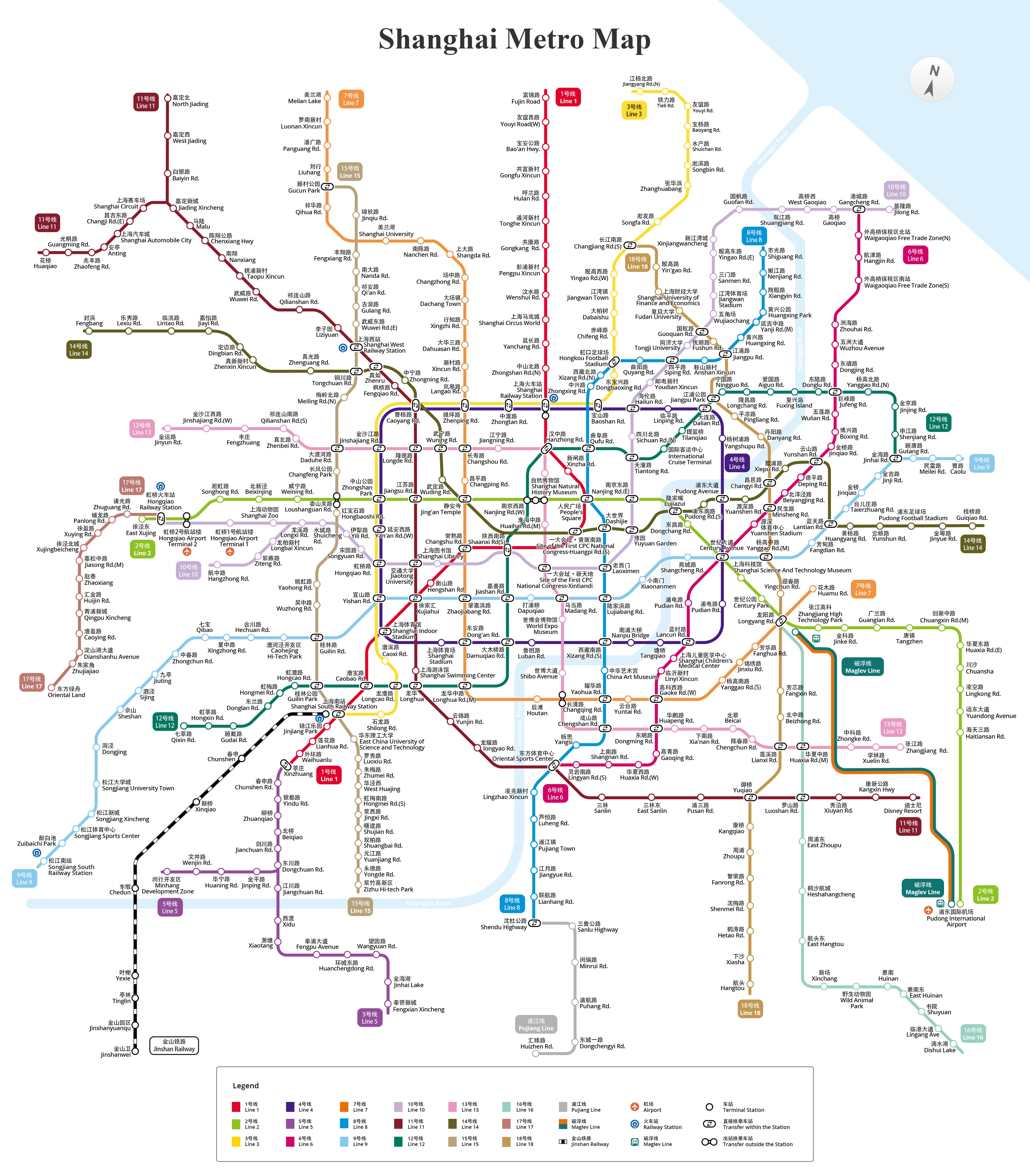
Shanghai Metro Lines
The Shanghai Metro is a rapid transit rail network that operates both underground and on elevated railways. Here's a simpler breakdown of its lines.
- Line 1 (Red): Fujin Road - Xinzhuang
- Line 2 (Green): National Exhibition and Convention Center - Pudong Airport T1 and T2
- Line 3 (Yellow): North Jiangyang Road - Shanghai South Railway Station
- Line 4 (Purple): This line is a loop line with no specific start or end station
- Line 5 (Blue): Xinzhuang - Fengxian Xincheng
- Line 6 (Magenta): Gangcheng Road - Oriental Sports Center
- Line 7 (Orange): Meilan Lake - Huamu Road
- Line 8 (Blue): Shendu Highway - Shiguang
- Line 9 (Magenta): Caolu - Shanghai Songjiang Railway Station
- Line 10 (Purple): Jilong Road - Shanghai Hongqiao Railway Station
- Line 11 (Light Brown): Huaqiao - Disney Resort
- Line 12 (Teal): Jinhai Road - Qixin Road
- Line 13 (Yellow): Jinyun Road - Zhangjiang Road
- Line 14 (Light Green): Guiqiao Road - Fengbang
- Line 15 (Light Yellow): Gucun Park - Zizhu High-tech Zone
- Line 16 (Aqua): Luoshan Road - Dishui Lake
- Line 17 (Dark Green): Hongqiao Railway Station - Xicen
- Line 18 (Silver): South Changjiang Road - Hangtou
- Pujiang Line (Grey): Huizhen Road - Shendu Highway Station
- Maglev (White): Pudong Airport T1 and T2 Station - Longyang Road
Shanghai Bus
Shanghai's public transportation system has 1,596 operating routes with a total length of 9,243 kilometers. Buses in Shanghai are an extensive and affordable way of public transportation. They serve as a crucial part of the city's transportation network, covering a wide range of routes and reaching various neighborhoods.
Types of Buses
Shanghai has different types of buses to cater to various travel needs. These include regular city buses, sightseeing buses, trams, and specialized bus services for specific purposes, such as airport shuttle buses and long-distance intercity buses.
| Type of Buses | Routes | Departure Stations | Destinations | Ticket Prices |
|---|---|---|---|---|
| Sightseeing Buses | Tourist 1 | Shanghai Museum | Shanghai Museum | CNY60 |
| Tourist 2 | May Thirtieth Movement Monument | May Thirtieth Movement Monument | ||
| Tourist 3 | Garden Bridge of Shanghai | Garden Bridge of Shanghai | ||
| Tourist 9 | May Thirtieth Movement Monument | May Thirtieth Movement Monument | ||
| Tourist 10 | Jinling East Road Dock | Jinling East Road Dock | ||
| Trams | T1 | Xinqiao Railway Station | Canghua Road | CNY2-3 |
| T2 | Songjiang University Town Station | Songjiang University Town Station |
Bus Stops
Bus stops in Shanghai are marked with a blue sign displaying the bus number and route information. Many bus stops have electronic display boards that show the estimated time of arrival for buses. You can also check bus route information and schedules on the Shanghai Bus Transportation website or through mobile apps.
Bus Fares
In Shanghai, the bus fare in the city is mostly CNY2. If you pay by bus card or scan a QR code, you can enjoy a CNY1 discount when you transfer to another bus within 2 hours.
You can also buy a 24-hour joint ticket for CNY19.8 on the Suishenxing 随申行 WeChat mini-program. With this ticket, you can take public transport in Shanghai as many times as you want within 24 hours. This includes buses, subways, and ferries.
Related reading: How to use WeChat or Alipay QR code to take a bus in Shanghai
Travel to Shanghai With Us
Our team of locals knows the city inside out. We arrange all kinds of activities, and besides our popular tours, we can customize itineraries based on your needs. Experience the best of Shanghai with our expert guidance!